
Most visitors to Singapore think of it as a compact urban state; densely populated, combining the old and new of culture, food, and architecture. However, stay a little longer and you’ll have a chance to explore beyond the obvious tourist sights and discover Singapore’s natural green beauty.
Green walks
Here are my four favourite green walks in Singapore – perfect for those looking to keep active whilst exploring Singapore. All of these walks are easy to moderate, although please do keep in mind Singapore is very hot and humid. Therefore do make sure you take plenty of water (maybe even a sweat towel!), insect repellant, comfortable walking shoes, suncream and a hat. And of course your camera!!
1. The Southern Ridges – Mount Faber and Henderson Waves
This is actually a 10km connector trail covering several of Singapore’s nature reserves and green spaces. This doesn’t mean you need to walk the entire length of the trail in one go, but rather walk the distance to suit your energy levels. The Singapore National Parks Board provide a very helpful guide of the entire route which you can find here.
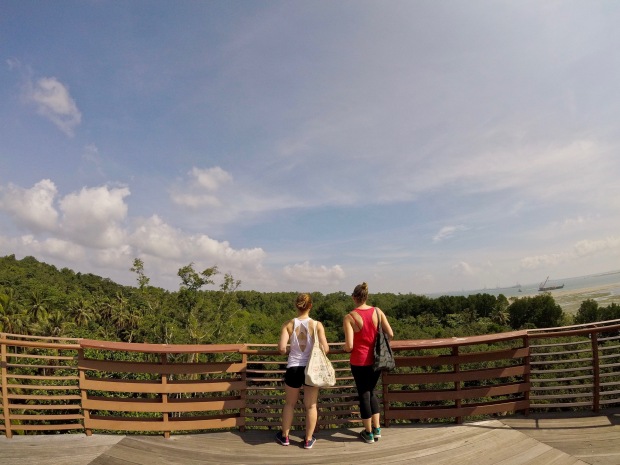
I recommend starting at Harbourfront MRT station and taking the Marang Trail pathway to the Mount Faber viewpoint. It is quite steep, with lots of stairs, but once you make it to the top you have some impressive views over Sentosa Island.

Faber Walk – you’ve made it to the top of the Marang Trail!
The viewpoint at Faber Point is usually the busiest part of the trail (with many tourist buses offloading groups here), so I suggest taking in the views and then continuing onwards. From the top of Faber Point it is only a 10 minute walk to Henderson Waves, following the stairs down from the viewpoint though the jungle. Henderson Waves is an impressive piece of architecture, and a real highlight of the trail.

The ‘wave’ design of the impressive pedestrian bridge
After crossing the bridge, continue along the track, following the signs to the Forest Walk. Another highlight of the Southern Ridges trail, the Forest Walk is an elevated walkway through the lush green space of Telok Blangah Hill Park.

The elevated Forest Walk; a lush walk amongst the tree tops; so peaceful you really do forget that the Telok Blangah Heights neighbourhood is right behind you (you can see the HDB buildings peeking through in the background).
Next you will reach Alexandra Arch Bridge. If you have the energy, continue onwards into HortPark. Otherwise you can opt to end your walk here on Alexandra Road (right next to the Gillman Barracks) which is a handy spot to order a Grab, or refuel with a beverage or food at the barracks.

The HortPark Canopy Walk offers another excellent trail in the treetops.
2. TreeTop walk at MacRitchie
The views from the TreeTop Walk are incredible. This suspended bridge is raised well above the tree line, allowing you to see just how expansive the green surrounds of MacRitchie National Park are. The best way to access the TreeTop Walk is to take the loop trail from the carpark at Venus Drive, which is quite an easy and relatively flat 6km walk. It’s worth noting that the remainder of the trail is not particularly eye-catching, and it can get extremely busy on weekends, however it does offer you that green escape from the city. You’ll need to book a cab or Grab to drop off & pick up from the Venus Drive carpark.

Keep an eye out for the friendly locals who like to hang about the treetop walk too
3. The Green Corridor
Also known as the Rail Corridor, this is probably the least manicured of all the green spaces in Singapore, but this is exactly why we enjoyed the experience. As of February 2019, The Green Corridor is under some major construction with only the central to northern section of the path open to the public. I recommend getting the MRT to King Albert Park, and then following The Green Corridor just under 6km to Bukit Panjang MRT Station. It is a good 1.5 hours of walking, which will take you past sections of the old train line, iconic train bridges, and plenty of picturesque green trails. Keep in mind this trail can get quite muddy following heavy rains, so dress accordingly.
4. Bukit Timah Nature Reserve
Reaching an elevation of 178m, Bukit Timah Hill is the highest point in Singapore. It is no mountain by any means, but it does make for a nice walk to get your heart rate going. There are two routes to the top – one is the short and (not so) sweet way which essentially is a steep stairway straight to the summit. The other route is a much more enjoyable gradual incline and surprisingly a quieter track too. To follow this path follow the signs for the South View Path (or green route per the National Park map). There is a really handy map and write up in this blog by The Smart Local.
Once you’ve successfully hiked to Singapore’s highest point and made your way back down to the entrance of the park, reward yourself with a short 5 minute detour to the Hindhede Quarry. Located in Hindhede Nature Park, it is a beautiful and peaceful place to rehydrate while taking in the views. You will see signs outside the Bukit Timah Visitor Centre directing you to the Quarry. Look out for the local turtle inhabitants.

To get here; catch the MRT to Beauty World, and then it is a 10 minute walk to the Bukit Timah Nature Reserve Visitor Centre.
Bike rides
1. Marina Bay & East Coast Park
This is my favourite cycle route in Singapore, taking in some of the key sights around Marina Bay plus also taking you along the green and peaceful East Coast Park cycle path. We always hire our bikes from The Bicycle Hut located on the north side of Boat Quay, just off North Bridge Road, which offer sturdy and easy-to-ride bikes at a great price.
Once you’ve got your bikes you can follow the path along the river, past the Civic District, and across the pedestrian bridge over to the Fullerton Hotel. You’ll then need to cross the busy Esplanade Drive, where you come to the Merlion, and then follow your way around along the Marina, over the Helix Bridge, and onwards to Gardens by the Bay. Either choose to explore the Gardens, or continue along the water bike path towards the Marina Barrage.
Once crossing the Barrage, you’ll then cycle along Gardens by the Bay East where you’ll find some of the best views of Singapore’s stunning Marina skyline.

This path connects on to the East Coast Park bicycle track, where you’ll be surprised just how green and peaceful the park is which runs right alongside Singapore’s coastline.

It’s quite a long loop from The Bicycle Hut, so I would recommend starting the ride mid-morning and making a stop at ECP for a lunch break. We generally stop at The East Coast Lagoon Hawker centre (our furtherest point before beginning the same route back) which has just about the BEST popiah in all of Singapore, as well as excellent duck or chicken rice, and wanton soup. The perfect way to rest those legs and refuel for the return ride.

If you have the energy, make a small detour onwards to the Bedok Jetty to see the local fisherman and excellent views of the many cargo vessels off the coastline.
2. Day trip to Pulau Ubin
Pulau Ubin is located just off the East Coast of Singapore, a quick bumboat ride from Changi Village ferry terminal (officially called Changi Point Ferry Terminal). The island is known for being one of the last kampongs in existence in Singapore – a chance to see how Singapore village life would have once been.
This makes for a fun and adventurous day out; starting with the 15 minute boat ride over to the island, then hire yourself a bike from one of the many stalls. As you can see from the map below, there are many areas to see across the island, but if you’re planning for a half day visit you’ll need to pick only one section to explore.

I highly recommend heading towards the Chek Jawa wetlands, where you can park your bike and take the scenic boardwalk loop. Also make sure you climb the Jejawi Tower to get a view over the tree line along the islands coastline. It really is a beautiful view. For more ideas and information, check out the Time Out guide or the write up by the honeycombers.
View from the top: Jejawi Tower

The boardwalk at Chek Jawa wetlands
I recommend heading to the island in the early morning to beat the crowds, which also means you’re likely to time it perfectly to arrive back to Changi Village for lunchtime. There is a huge variety on offer in and around the hawker centre, but if you also enjoy your craft beers, I recommend a stop at the Little Island Brewing Co. Plenty of pub fare on offer for food along with about 6 taps of craft beers and a cider (which you get to pour yourself!).

I almost perfected the pour…

I think we’ve done the Southern Ridges!
LikeLike
Yes, you sure have Ron 👌🏻
LikeLike
Absolutely loved 🚲 the Marina Bay & East Coast Park route with a stop at the East Coast Lagoon Hawker for some lunch and a sneaky beer…followed by a well deserved swim at home! Thanks so much @travelbestshared !
LikeLike